My Rides
Big Man Bike Shorts
As a big man I've had a hard time finding bike shorts that doesn't cut me in half, while I found a place that sells Big Man Bike Shorts and other stuff with sizes up to 5XL. I bought a bib short and it fits great. The web site sells more than just big man stuff and the link goes to the home page, to get to the big stuff, click on the menu item at the top.
Overview
I've been doing serious riding for fun and exercise since I bought my first 10 speed in
1972, now I have a bike with a 30 gears, a TREK 5200. As such, I have ridden over several decades and
thousands of miles on roads and bike paths. Since I started serious riding BMB (before mountain bikes) I
have mainly been a road biker, although I have a cheap mountain bike to ride in ice and hard snow during the winter.
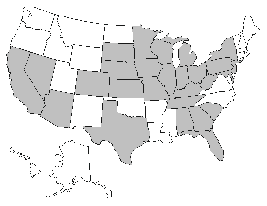
As a road biker I look for pavement. The following is a list of states and places I have ridden.
On August the 17th of 2010 I was in another serious bicycling accident, this kept me off a bike for a long time and now as I get back into riding I'm riding a three wheel recumbent. I find this harder to ride as far or fast but as I adapt I hope to improve my recumbent riding ability.
Some information may be dated and is subject to change as population density and driving patterns change. Bicycling also involves elements of risk and as such riders should use proper safety equipment such as helmets, obey all the traffic laws and never ride while impaired.
Florala — 12•30•07
Stayed in Florala Alabama on trip to bag the high point of Florida. Rode in the morning in the dark and rain around lake Jackson which was 3.6 miles and is in both states.
You can ride the loop as many time as required.
Craighead State Forest Park — 5•20•19
Stopped at Craighead state park and rode a couple miles. The park has paved bike trails but is hilly then I expected.
Gila Bend — 5•27•07
Stop there on a trip to California and stayed at the Space Age Motel, nice place. Mapped out a route that whould have given me a nice loop, that was north of the motel
San Clemente — 5•28•07 — 5•31•07
Stayed at the Beachcomber motel while in San Clemente which
was on a hill. Did two rides north and south. The south ride went along I-5 following
bike lanes and bike route signs, it was an out and back. The north rides also was
following bike routes, the San Clemente section wind and turned through town until it
arived at the Pacific Coast Highway which had bike lanes, that I rode north to the state
park. The Pacific Coast ride was flat and easy coming back with a tail wind. The wind
tend to be out of north west.
Redlands — 6•1•07
I stayed at the Comfort Suite Inn and rode east on Cofton to my grandfather old house.
The out is all up a grade at the end of road I turned left and then right on the next
east going road. I did this until I reached my grandfather old house and then turned around
and retraces my route which now was down hills. The biggest problem with the route was
all the 4 way stops that required stopping when there was traffic.
Colorado Springs (Sunday July 27 2003)
It was Sunday morning and few cars on the roads, I headed from the motel and biked up Canyon Park road to
about the 7000 foot level, the road
was getting steep and the altitude high for a flat-lander such as my
self, so I turn around and di a toured Colorado Springs.
Mineral Belt trail. (July 28-29th 2003)
I was in the process of preparing
for the ascent of Mt. Elbert and
was staying in Leadville which has an excellent paved bike trail called
the
Mineral Belt trail, the trail is a loop around Leadville, the west part
traverses the town and then heads into the forest, and the unique thing
is the mining machinery that decorates the trail.
I
was able to jump on the trail from the Super 8 where I was
staying. The trail goes through the town and then up into the
mountain, it was good pavement. It was a great trail and if you
ever find yourself in Leadville with your bike, you must ride at least one route.
Overall I find the roads in Central Florida narrow and heavy traveled;
it is not my favorite place to ride, I found the Tampa area to be
better.
Coast to Coast Ride - Ormond Beach to Yankeetown (Dec
29 1986)
My wife and I started from Ormond Beach by touching our wheels in the
Atlantic
and headed west (the wind was slightly out of the west that day). My wife road the first 50 miles and then joined my
niece who was driving sag. I finished in Yankeetown before
sundown by touching my wheels in the Gulf. We saw the sun rise
over the ocean and set in the gulf. We followed route 40
which I found narrow.
Orlando Area
In previous trips to Orlando I did not have much success in finding a
good place to ride, I could make do, there were some bike
lanes, but it was hard to put together a good long rides. However, on my last
trip (March 2006) I tried the
West
Orange
Bike Trail, that turned out to have been the best riding I have done in the Orlando
area. The first 3 rides I started at County Line Station, the problem I found with that was
around 4 ½ miles the trail went through Winter Garden, a nice town, but the trail crossed
too many streets and had obstacles that slowed the riding down. So the next two times I started
at the Winter Garden Station on the east side of town and I avoided the slowness of riding through
town.
Tampa Area
I had flown down to Tampa with my wife and stayed in Zephyrhills and
did not have my bike with
me, so I went to Wal-Mart and bought a cheap $50 bike that I rode
during the week and gave away before leaving. Because of using such a inferior bike I only rode
around the resident roads. My next trip I plan on bringing my
bike and ride the
Withlacoochee
trail
that looks interesting.
Savannah
On my way to Florida to do the
Coast to Coast Ride we stayed out side of Savannah, so early in the morning, I
just rode around the streets doing miles. I did not find any great
places to ride but had no trouble with traffic.
North Central
On the way back
from Wisconsin we stayed at a Motel
in North Central Illinois,
I rode early around roads I could find near the Motel.
Shelbyville, (Summer of 1987)
I did a triathlon there.
Lamoni, May24, 2015
Road the bike trail, it was raining, the trail is concrete which meant there was expansion cracks
that made the ride bumpy, didn't ride far because of the rain.
Junction City (Saturday Jul 26 2003)
I stayed at a motel off of I-70 exit 299 went south on J Hill
road and road around in the country. It was a little windy but
typical country roads although not a flat as you might expect of Kansas.
Only had a problem with one dog.
Ford Road — 8•27•06
We were staying at the Hampton Inn in Winchester off of exit 98 of I-64. When checking in we asked
about a place to ride and the clerk suggested the place that she liked to ride. The ride was on the
east side of the Kentucky River across from Fort Boonesborough State Park on Ford road. From the
motel we drove south on 627 to Ford road turned left just before crossing the bridge and about ½
on the left is a Resturant called Bananas on the River. The ride was on Sunday morning starting at 7:30
and there was no one in the parking lot. We had been told by a the clerk that it was ok ot park at the
resturant and at that time of the morning there was no one to check with. We did an out and back ride
going south following first the river and then Four Mile Creek, both flow north at this part.
The road starts as a two lane but narrows into a wide one lane back country road.
Followed Ford Road South it turns into Four Mile Rd and follows four Mile Creek and dead ends, turn left onto Bybee Rd and climb the hill
Arnold
Lived in Arnold from Sept 1990 to Sept 1991, I rode to work in Annapolis
several times and rode both the road and the bike trails in the area.
The only problem I had was an assault by two guys in a truck that hit me with a half full beer can.
Marquette 5.27.06
When traveling through the Upper Peninsula we stopped at the Days Inn in Marquette on SR 41. The next morning I was
up before day break, 6:00 AM, and headed out for my ride. I rode across the SR 41 and up the hill, made the
first left, then rode to the T, turn edright went to the next T and then turned right again, I was heading for
Lake Superior. This lead to a down hill with a 8% grade which I had to climb on the way back and straight on to
Lake Superior. At the end of this road I turned right and was rewarded with a beautiful sun rise over Lake Superior,
which I was able to enjoy as I cruised along the shore. There was a bike trail there but I found the road more
enjoyable. On the return trip I saw other bike trails crossing the road but no time to explore
The Upper Peninsula has some potential for riding but I suspect it gets cold in the winter time.
Lutsen 5.27.06 and 5.28.06
Next stop that day was the Best Western in Lutzen Minnesota. The motel was called the "Cliff Dweller" for a good
reason, it was on the side of the lake, every room was lake side with a balcony and a great view. I was glad with
our choice. After checking in I rode a short ride to get a feel of the land. I rode south on SR 61 and hopped on
the Gitchi-Gami Bike Trail when possible, Minnesota
is putting an effort in building this trail along SR 61. There was some long sections that we passed and some
under construction. Check it out if you are in the area.
The next day we was climbing Eagle Mountain, so the plan was for a short ride early in the morning. This time of year
and this far north the days are long and the sunrise early. Sunrise was at 5:10 AM CDT with
civil twilight being around 4:30. Therefore I was out on the road by 4:50 heading back the same way I did the
evening before, this time I went a little far and followed the trail as it left the road and headed into the woods,
but Eagle Mountain was ahead of me so I turned around, head back to the room, packed up, drove to the trail head
and climbed the mountain.
Fulton — 5•21•19
Stayed overnight at the Holiday Inn Express on the way to Florida from KCMO. Rode a few miles in the morning.
Warrenton — 6•4•07
Stayed at the Ammerihost Inn and rode the access road parallel to I-70 for
an out and back.
Kansas City MO
Since my daughter and family has moved to KCMO, I have taking my bike when visiting her and have looked for a place to ride.
Overall KCMO is very hilly with too many ups and down for my old legs but I have found a few flat places to ride. One is the Platte Landing Park, where you can do a
two mile loop and repeat it as many times as you want, good if you are looking for training.
The other is at Charles B Wheeler downtown airport. I rode there on July 4th and there is a loop around the airport of about 3.5 miles. There were other cyclist
riding there.
Norfolk (summer of 1976)
I spent the summer of 1976 there and casually rode in the town, It was a small
city and easy to ride in and avoid traffic, although that was a long
time ago.
Las Vegas — 6•2•07
Stayed at the Comfort Inn across from the Hard Rock Casino and rode in the morning before leaving. I just rode around a
couple of the blocks not going very far from the motel just repeating the loop.
Summit
I lived in Summit from Nov 2003 to Nov 2005 on Morris Road near Edgar St. My usual rides was to head west out
of town on Springfield Avenue, I would ride east on Morris to Kent Place Blvd, turn right and ride to Passaic Ave
which was the first traffic light. I would then turn left, down the hill under the train overpass and turn right
onto Constantine Pl which lead up a short steep hill to Springfield Ave, turn right and head west. I could follow
Springfield Ave (SR 512) which changed into Valley Road. This would continue to about 10 ½ miles until it
joined with King George Rd in a tee, 512 continued to the right and then left at the next traffic light.
I would ride until I made ½ my mileage goal and turned around and head back. Sometimes I would ride
Long Hill Road by turning right at Synder Ave and then left on Long Hill Rd, ride to Northfield Rd turn right to
Valley Rd, left back to Summit.
Summit itself need to fix it roads, the condition of the pavement is
bad. I never had any trouble with the traffic on Springfield Ave, the street
is wide and easy for the cars to pass except the further west where the
road narrowed in different parts but again no trouble with the
cars. This seemed to be a well traveled route for cyclists, and there is an excellent Bike shop in
Stirling along Valley Rd called High Gear Cyclery.
Sandy Hook
Sandy Hook National Recreation Area is a good place to ride but can be windy since it is exposed to the
ocean. It has a well maintained bike trail and I have ridden both the trail and roads in the park. The biggest
problem is the bike trail is only around 5 miles long, so either you can do several loops or head out of the
park and then ride back.
Parking in the park depends upon the seasons. During the summer season (Memorial Day to Labor Day)
there is a charge of $10 per day or $50 for a season pass. Also on weekends during this time the lots will
fill up early.
New York City
My rides (2 to date) in New York City would start in New Jersey. Both times was on Sunday morning and I would
park on the street near the George Washington Bridge, I would ride across the bridge and
down the Hudson
on the bike trail; it was an interesting ride with the biggest problem
is that foot traffic increased on the trail as you approached downtown.
I have lived in Central Ohio since 1982 except for a year in Maryland and 2 years in New Jersey. I
have lived in several different towns on the east side of Columbus. Central Ohio is a good place to
ride for the most part. However, since this is where I have ridden the most
miles, it is also where I've had the most problems.
Sept 13, 1985 East Broad St.
I was hit from behind by a Honda Golden Wing motorcycle, spent 11 months on crutches,
3 times in the hospital and 2 operations.
Sept 13, 1994 Goose Lane
As I was riding west on Goose Lane
for my first time, came down a hill too fast to make the sharp right
hand turn at the bottom and went off the road. The results was a
concussion and an ambulance ride to.
Irate Motorist
Several times I had motorist become angry just for being on the road, I was obeying
the laws but they did not like to share the roads. From these experiences I have
discovered what was the best roads and times to ride.
Good places to ride
Bike Trails
If you like bike trails check out the following
link.
KoKosing Gap Bike Trail
Refugee/Palmer road loops
I like riding Refugee road (in Liking County just north of I70 not to be
confused with Refugee Rd in Columbus) going east and then turning south
to Palmer for the return trip. You can cut south from
Refugee to Palmer in several places. The following are
roads that I have found reasonable to ride between Refugee and Palmer; starting
east. Columbia to route 40 to tollgate. This is usually my return route back to
refugee, there is about a quarter miles of route 40 but you can
ride the should. Next cut south is 310, avoid this and
use Smoke, then Watkins but avoid during school hours, York is good,
then Outville road which I avoid. Then after that is
Gale. If I doing a loop to Palmer I use this to route 40
and then travel east on 40 (shoulder) to Swamp and south to Palmer.
If you want a longer continue to Hebron, Refugee ends in Hebron
with a right turn that becomes 9
th street, ride south to
route 40 and turn left Go to the 2 second traffic light and
turn right this is High Street, make the next right that takes you to
Canal St about 100 yards, turn right. Follow Canal St to Lakeside
Rd, first right after crossing route 69, follow Canal St to Millersport
Rd turn left on Millersport Rd and follow it through town to Bickel
Church road, turn right. Follow Bickel Church, it will cross route 37,
then to Cherry lane, turn right, go north, to Stemen Rd, turn
left. Follow Stemen to Snyder Church to Blacklick eastern, turn
left then take the next right (north) and then the next left and you
are on Palmer between Watkins and Smoke.
Parking can be done several places along the route with the best option is in
Pataskala.
There is public parking on Front Street between 310 and Township Rd by the railroad tracks.
Turn right coming out of the Parking Lot then turn right onto Township Rd going south, this
will lead you to Mills St, turn left. Somewhere the road names changes from Mills to Creek Rd.
Creek Rd will lead you to Smoke or down to Watkins, by turning right on either of these roads
you will cross Refugee, from there make a route.
The City Of Westerville
I used to work in Westerville and sometimes would ride the
Bike Trails after work or during lunch time.
My normal route consist of start at the Westerville Sport Complex at the
junction of Cleveland Road and County Line Rd, west of Cleveland, south of
County Line. I'll park there and change in the restrooms and head north
to BikeWay 4, turn right and head east. BikeWay 4 stops at BikeWay 1
and I turn north crossing County Line which is dicy since there is no
lights and traffic.
I go north on 4 to BikeWay 22 turn right and head east. If you go straight
on BikeWay 4 it becomes BikeWay 14 and follow it to the second right which
is BikeWay 3. That goes first east and then south east and crossed
County Line again after which at some time it Becomes BikeWay 7. Go east
until you come to Sunbury Rd, the BikeWay turns south and is BikeWay 9 on
the map, it looks like a large sidewalk.
The bigest problem with this BikeWay is that the bikeway goes under the road
and it's easy to miss the turn. The path is on the west side of the road
until it comes to Marlene Drive, turn right before crossing the road and
then right again and the path goes under the road and popup back on the east
side. From there continue south until either on of two choices. One
is to continue south to Central College Rd where the
bike way currently end, turn around and head back.
The other is when you rach the Dam you can ride across on the walkway and
then turn left and go
up the hill to cubbage, turn left head north to Walnut, turn right head
east.
Once on Walnut you have several choices depending upon how far you wish
to travel. You can turn left unto Schott and head north for some hills
or continue east on Walnut. From these road there are a multitude of
possible routes to ride.
For the return trip I retrace my ride until I come back to BikeWay 10
the "Westerville Bikeway", instead of turning south I turn north and
head to the BikeWay 5 the "Polaris/Maxtown Road Bikeway" and turn left
going west to Cleveland Avenue, and head south. Currently the
sidewalk/bikeway is closed part way done so I cross the road to finish
the trip.
The Alum Creek Greenway
Another ride I'll do from work also starts at the Westerville Sport Complex, but
for this ride I'll head south to the
Alum Creek Leisure Path
also known as
the Alum Creek Greenway. The bike trail heads south along Alum Creek and enters
Columbus making it much more than the 1.7 mile Westerville portion. At the current
time I have only riden to just south of Morse Road but plan to explore more in the
future.
One of the better part of this trail is the limited times it crosses a road. The first
crossing is at Main St. in Westerville, the second at Westerville Road. The rest of
the time the trail goes under the road bridge along the creek. When the creek floods
these parts of the trail are not available but the path have a bypass that does require
crossing the road.
Clarksville
Located in Southwestern PA, NE corner of Greene County
Clarksville is my home town and it is in a
valley with serious hills to climb any which way you go. The
longest you can go is about 7 miles before you hit an out of the saddle
climb. The hills are not long but they are steep, and
often. If I rode east I would get into two steep climbs in the
first mile and have a top speed of around 45 mph. This area
is where I hit my top speed of 53 mph.
In addition to riding the road there is the
Greene River Trail.
The trail is crushed stone which is very small and I have ridden the trail twice on my road bikes which has 700x23c tires
and had no problems, it not as fast as pavement but the trail can take you to Rices Landing without doing major climbs.
Allentown (October 2003)
I stayed a weekend in the Super 8 motel at exit 45 of I-78, this was reasonable place to stay with reasonable
price. I could from there get ride country roads.
Uniontown/Hopwood (August 2019)
I was staying at the Summit Inn for my 50th year High School reunion which is on top of a mountain. In my younger and lighter years I may have rode the Skyline Drive from the hotel but I wanted a flatter route. So I drove down the mountain to Hopwood and went looking for a place to ride. I the stumbled across a bike trial which was the
Sheepskin Trail. It turned out to be a nice trail. I couldn't find it on google maps but it can be picked up at the Hutchinson Recreation Area.
Columbia — 1•6•8
Stayed at the Hampton Inn on Barbara Dr off exit 17 off  . Since we was going home and had a long day ahead of us I was up early and riding
in the dark using my lighting system. I first went left out of the parking lot but the road quickly became unpaved so I turned around and headed to the main road Route 1. I crossed over into Nates Rd and followed it into a parking lot so I circled 2 times and headed out came back to Tremholm Rd Ext turned right and then took the next right on Oakcrest Rd which goes about 1 mile to Windsor Lake Blv. I had two choices left or right, I turned right and followed it for a little bit and turned around not want to get too far from the Hotel. So I went back to the Hotel but wanted more mileage and gave the unpaved road a try. I about a ¼ mile it turned back to pavement, I continued to Edgewater Dr, but my time was up and back to the Hotel I went, packed and headed home.
. Since we was going home and had a long day ahead of us I was up early and riding
in the dark using my lighting system. I first went left out of the parking lot but the road quickly became unpaved so I turned around and headed to the main road Route 1. I crossed over into Nates Rd and followed it into a parking lot so I circled 2 times and headed out came back to Tremholm Rd Ext turned right and then took the next right on Oakcrest Rd which goes about 1 mile to Windsor Lake Blv. I had two choices left or right, I turned right and followed it for a little bit and turned around not want to get too far from the Hotel. So I went back to the Hotel but wanted more mileage and gave the unpaved road a try. I about a ¼ mile it turned back to pavement, I continued to Edgewater Dr, but my time was up and back to the Hotel I went, packed and headed home.
Custer — 7•31•3
I just rode out of town and into the country, some
hills and buffalos, interesting ride but only around 20 miles.
Route 61— 7•15•13
Staying at Dale Hollow in Kentucky, drove to Tennessee and just across the border park along side the road and started my ride. Route 61 has a good shoulder as wide as a lane in TN not in KY so I rode on the shoulder and it was a good ride, it was before 7 AM on a Monday morning and at time traffic was light even though the shoulder was a very good bike lane, google maps should it as a good bike route.
Amariallo — 5•26•07
Stop there on a trip to California at Soncy. Stayed at the Comfort suites and rode south turned into Westgate Mall rode around it twice and then back north toward the motel but continued north on 335 which I should have done in the beginning, it had wide shoulder that I used as a bike lane. Turned around when my time was up and back to the motel. When continuing the trip west I noticed a road running parallel to I-40 that looked like it would have been a good place to ride, I even saw three riders on it.
Virginia Beach — 9•5•16
Stayed at the Hamptin Inn Oceanfront North which is on the beach and have a bike trail in front of it. There was still wind from TS Hermine which wind 10-15 out of the NW so I rode north on the bike trail but it ended about a mile but followed the sidewalk to the next cross road that led to a ally that I followed for another mile before it ended then cross over the road to an access road that many was using for exercising. Followed it for about 3/4 of a mile and then turn around and return. Good ride.
Allegheny Highland Trail — 8•26•6
West Virginia is a mountainous state with lost of roughed terain and as such
favors mountain biking over road biking. Never the less I was determine to find a
place to ride my road bike. Most of the bike trails are unpaved and geared to mountain
biking however, the Allegheny Highland Trail southern end located in Highland Park near Elkins starts out
paved for the first 3 miles. My wife and I rode the paved part north until it came to the unpaved which
we rode for about a mile and a ½ before turning around. The problem was not the pea size gravel
but there was only two small strips with grass between them. We then went back to the trail head turned
around and did the paved part again and then tried some of the side roads.
Medford — Memorial Day 5•29•6
Passing through we stayed at the AmericInn in Medford. Sunrise is early this time of year and there was a heat wave
therefore I was up and riding by 5:30 AM. The wind was out of the southwest, so I rode south and west to start, I
traveled down SR 13 to CR O and went west, rode until I was tried of traveling in that direction and turned around
and came back, before reaching SR 13 I turned left (south) onto Gibson ave and went south again. This lead to a
large hill (for Wisconsin) and at the top I turned left (north) and rode Apple Ave back to SR 13, turn left (north)
and headed back to town where I just rode around exploring. Since this was a holiday morning the traffic was light
although more this I thought, I believed that all reasonable people should be still asleep. The road conditions
was ok but needed resurfacing, lots of cracks. The cars was respectfull and gave me wide berth. Overall not bad.
Madison — 8•3•3
Returning from the Mt. Elbert trip, stayed in a Motel on Sunday night road around the city
roads before returning home.
Neenah
Went to my niece wedding and rode in the country going west. Reasonable contry roads.
